Figuring Out What an Acre Looks Like on Google Maps
- Justus Hayes
- Jun 12, 2020
- 3 min read
It turns out I am a very silly man. Please disregard all the entry below the dashed line. Well, read it if you like, it's entertaining I think. But it's a very roundabout route to a solution that is not nearly as simple as it should have been. It turns out that the Google Maps measuring tool lets you measure area as well as distance. I'm sure most Google Map users know this, and I now count myself among them.
In Google Maps, right click on the map where you want to start measuring, and select "measure distance." Then left click your way around the perimeter, with each click creating a segment. Creating lots of segments allows you to approximate curves and irregular sections. When you have worked your way all the way around the perimeter, make a final left click on your first click. The window directly below will tell you the length of the perimeter and the area in m. So frickin easy.
-------------------------------------------
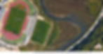
I first noticed that something was going on distance-wise on Google Maps when I produced this screen cap graphic while trying to figure out just what an acre looks like:

I'm always looking at these satellite images of property, noting the square meters given for the size of the plot, and then trying to guess boundaries of the property given that info. I'm most familiar with acres, but I don't have a good intuitive sense of what an acre looks like on a map. That is complicated by the fact that all European measurements are, of course, in metric.
To bring a little personal clarity to the problem, I decided to define an acre on a Google Map, just to see what it looks like and put it context next to things like roads and buildings. The result is the image above. The numbered and graduated white scale on the map is the measuring tool on Google Maps. Above, I measured out close to 64 m, because 64x64=4,096, and 4,096 meters squared is very nearly one acre (it's actually 4046.86, but close enough for government work). As soon as I did that and looked at it, I thought, "Hang on, that seems small." My suspicions were further aroused when I saw that the pdf had a handy scale ruler in the lower right corner - again, see above. Here is the direct comparison of those two scales:

The lighter rectangle is the indicated 20 m scale, which measures 40 m on the Google Maps measurement tool scale. I trust the pdf scale more at this point, so using that I will plot out one acre:

That is an acre. Sorry for the weird positioning, just how it worked out. This looks a lot better to me and seems about right. But what if the scale on the pdf is wrong? In fact, the more that I look at it, the more that seems a little big, maybe. Now I have to find something that can be seen from space that I can accurately know the length of, preferably in meters. Outdoor race tracks come to mind... Ha, this is even better and very appropriate:
That's the Estádio Municipal de Lagos, and it's dimensions are 103 x 64 m. It would be a lot easier to figure this out if one of the fields were straightened:
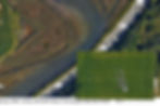
Curiouser and curiouser. It looks like my instincts are terrible. According to the pdf scale, that football field is only about 50 m long, not 103 m. Ok, back to the Google Maps measuring tool. Maybe that was accurate after all?

It's hard to read unless you zoom in, but that is 104.15 meters. Close enough given that I am making these measurements from freaking space. The Google Maps measuring tool is accurate. But that means an acre is tiny! After thinking about this just a little bit more, I realized I was probably trying to reinvent the wheel. Of course people would want to be able to measure the acreage of property using Google Maps. Sure enough, one option of many, Google Maps Area Calculator Tool.

It turns out that an acre is much smaller that I thought. Good to know.