Zones of Exclusion - Pixelated Rendering Blast Areas in Paris
- Justus Hayes
- Aug 14, 2020
- 4 min read

I found this interesting. I was well aware that Google Earth has only rendered portions of the planet. Mostly higher density areas of population, notable cities and towns, landmarks, that kind of thing. This results in long borders that transition uneasily between flat 2D landscapes, usually darker for some reason, and the 3D rendered areas. I am particularly amused when the border runs through the middle of a building or structure.

This image was snapped somewhere in Central Algarve's Barrocal region. Note the two-story red roofed house that appears to have nestled within it a 2D version of itself. Note, too, that this border also demarcates a change of season, which is fun (see this article for more on this).
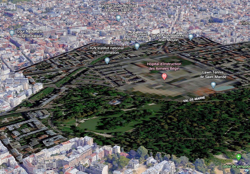
At any rate, I was wizzing around over Paris (really have to come up with a good verb), looking for rendering glitches to post on my Instagram, when I noticed a number of large dark patches. From a distance, they looked like massive bomb craters, irregular dark circles many blocks wide. Hm, what are these? A closer look revealed something I had never seen before, and that is big chunks of landscape obscured by huge pixels. And I mean huge. These may be the biggest pixels ever, relatively speaking. Hang on, I have to do some measuring.
...
Ha! They are approximately 14 m on a side, or about 46 feet.

It's obvious as to why this is; the pixels mask government buildings and have been placed for reasons of security.

This has been applied to French military hospitals, military barracks, prisons and government complexes. Got a hankering to plan a raid on the Ministry of the Armed Forces? That's a stupid idea, but it's an idea that will not be abetted by the use of Google Maps and Google Earth. In one sense, these are rendering blast zones and the metaphor works very well. Ground zero has the most damage in resolution, surrounded by a circular area of lesser resolution loss. Another really good metaphor is that they are like fortresses from the middle ages. The pixelated area is the keep, or central and most secure parts of the castle; the surrounding 2D area is the bailey; the transition from 2D to 3D is the curtain wall.

Reconstruction of Old Sarum; photo in the Creative Commons by Kurt Kastner
As I thought about all this, I couldn't help but wonder if other countries do the same thing. Here's a pic of Matsqui Institution, a medium security prison, and other correctional facilities in Abbotsford, British Columbia. I spent a couple of years collecting data at Matsqui for research on psychopathy when I was in grad school, and a couple more years working at the facility on the right, what used to be called the Regional Psychiatric Centre (RPC) but is now referred to as the Pacific Institution / Regional Treatment Centre. No pixels there. It's true that it is rendered only in 2D, but that's true of the area in general.

Still, the French have suffered many terrorist attacks, and it's understandable that they would take some extra security precautions, while Canada has escaped pretty much unscathed in this regard. Perhaps this is an unfair comparison. So what about America? It's hard to think of a country more obsessed with terrorism. Here is Rikers Island, in New York:

Not only not pixelated, but 3D rendered as well. Hm. But this is a prison, not a military installation or a department associated with defence. Here's the Pentagon, not only the Department of Defense (I bow to the American spelling), but also the site of a terrorist attack. No pixels.

(Sweet Jesus, but that is a lot of parking. Imagine being the poor sap in the furthest spot.) The Pentagon is also only rendered as a 2D image, as is the whole area, and I can imagine that this is a request/demand from the United States government. "Hey, let's not make it too easy..."
All right, one more. How about Britain? I already know the Houses of Parliament are 3D rendered, but what about a military installation? Here's Colchester Garrison Military Corrective Training Centre (MCTC) in Essex, England.

Just because it's interesting, and a great example of the nuggets I learn while writing this blog:
"...an important military base since the Roman era. The first permanent military garrison in Colchester was established by Legio XX Valeria Victrix in AD 43 following the Roman conquest of Britain. Colchester was an important garrison town during the Napoleonic Wars and throughout the Victorian era. During the First World War several battalions of Kitchener's Army were trained there. Now, 2nd Battalion and 3rd Battalion of The Parachute Regiment are based there." (Wiki)
No pixels and rendered in 3D. I suppose we are left to draw some conclusions about the French attitude towards security, i.e., thumbs way up. More than two thumbs, if possible. I'm going to finish this off with a couple more from Paris and the definition of "exclusion zone," which I looked up to make sure I know what I'm talking about (ha!). Stay safe! Or, as the French say, rester en sécurité!

Prison La Santé - (Wiki)

Ministère des Armées (Ministry of the Armed Forces) - (Wiki)
"An exclusion zone is a territorial division established for various, case-specific purposes.
Per the United States Department of Defense, an exclusion zone is a territory where sanctioning body prohibits specific activities in a specific geographic area (see Military exclusion zone).[1] These zones are created for control of populations for safety, crowd control, or military purposes, or as a border zone, and they may be temporary or permanent." (Wiki)


Comments